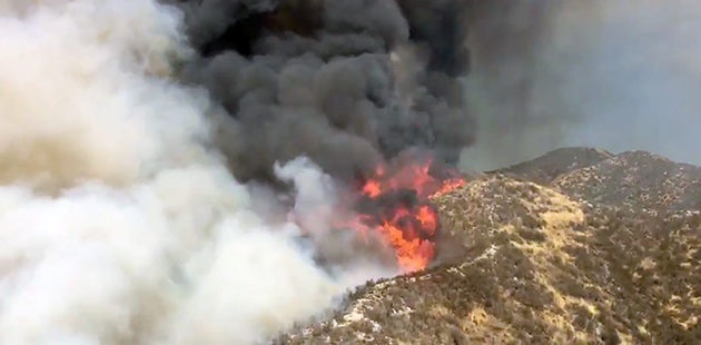
Sand Fire burning north of Angeles National Forest
The Los Angeles County Fire Department has been fighting a wildfire that began around 2:15 p.m. just north of the Angeles National Forest, near Santa Clarita. It started near Highway 14 and Sand Canyon Rd.
It’s a fast moving fire that has already consumed 3,327 acres and as of 9:30 p.m. is zero percent contained. To gauge the speed of the fire: the LACFD reported at 9.m. the fire had consumed 2,500 acres.
 Some evacuations have been ordered as the fire is sweeping in a southeasterly direction. Both directions of Highway 14 have been closed and the Metrolink has stopped traffic through the Antelope and San Fernando valleys.
The quick spread of the fire has been aided by high winds and triple digit temperatures in the area. The heat wave is expected to continue.
There are over 300 people, 29 engines, 12 hand crews and 13 aircraft employed in fighting the fire. It is so large people in Orange County can see the fire.
People on Twitter are using the hashtag #SandFire to post their photos of the fire, from all over the Los Angeles and Orange County area.
Evacuation center for residents is Golden Valley High School, 27051 Robert C. Lee Parkway, Santa Clarita, CA 91350. For large animals: Jack Bones Equestrian Center 29320 The Old Road, Castaic, CA 91384.
•••• •••• ••••• •••• ••••
UPDATE JULY 23, 6:45 a.m.: Evacuations ordered:
Capra Road off Soledad Road.
Additional evacuation areas: Unincorporated LA, Bear divide to Gold Creek on Little Tujunga are mandatory.
Gold creek area is voluntary. Approximately 200 to 300 homes.
•••• •••• ••••• •••• ••••
 UPDATE: JULY 23, 11a.m.: The Los Angeles County Fire Department is reporting, “… the Fire is approximately 5,500 acres and is 0% contained. Los Angeles County Fire and the Forest Service are in “Unified Command.” About 300 + firefighters are engaged in initial attack. Resources include 126 engines, 14 hand crews, 28 helicopters, 8 fixed wing aircraft and 7 dozers.”
Additionally: “The Santa Clarita area is under a Red Flag Warning. Crews will be experiencing temperatures highs of 106 degrees. Winds will be coming from the East at 10 MPH will gusts of 12 MPH. Humidity will be at 10%.”
Evacuations:
Mandatory Evacuations for residents living on Little Tujunga Canyon Rd above Gold Creek to Bear Divide.
Evacuation shelters: Residents — Golden Valley High School 27051 Robert C. Lee Parkway, Santa Clarita, CA 91350.
Large Animals — Pitchess Detention Center (Jack Bones Equestrian Center) 29320 The Old Road Castaic, CA 91384. Mandatory evacuations in place from Bear Divide to Gold Creek and along Little Tujunga Road down to the Los Angeles River Ranger District Office located at 12371 N. Little Tujunga Canyon Road, San Fernando, CA 91342. Voluntary evacuations are in place from Gold-Creek to Camp 16. Approximately 300 homes.
ROAD CLOSURES
Topanga Canyon: 1720 Topanga Skyline Dr
Lakeview Terrace-Kagel Canyon: Little Tujunga Canyon Rd, to Osborne
Angeles National Forest Canyon Country: Sand Canyon Rd. to Placerita Canyon Rd.
Angeles National Forest, Newhall Canyon Country: Placerita Canyon Rd to Highway 14
Acton: Soledad Canyon Rd. to Crown Valley Rd.
Agua Dulce Acton: Soledad Canyon Rd. to Agua Dulce Canyon Rd.
Agua Dulce, Canyon Country: Soledad Canyon Rd. to Highway 14
Agua Dulce, Canyon Country: Soledad Canyon Rd. to Shadow Pines.
UPDATE CORRECTION: The fire is now at 11,000 acres.
•••• •••• ••••• •••• ••••
UPDATE: JULY 23, 9:30 p.m.: The fire has now burned 20,000 acres. Evacuations have been expanded and air quality advisories have been issued.
Click Here for air quality advisories in the Los Angeles are.
The evacuation areas have nee expanded to include (for all residents):
Little Tujunga Canyon Rd above Gold Creek to Bear Divide.
Sand Canyon from Lost Canyon to Bear Divide (extended from Robinson Ranch Golf Course)
Placerita Canyon from the Nature Center to Sand Canyon
A new evacuation center has been added: Hart High School, 24825 N. Newell Ave, Santa Clarita, Ca, 91321
The fire is 10% contained.
•••• •••• ••••• •••• ••••

UPDATE: JULY 24, 7:30 A.M.: An update on the Sand Fire which has now grown to 22,000 acres.
There are now more than 1,000 people fighting the fire. The Unified Command (Angeles National Forest, Cal-Fire, Los Angeles County Fire Dept) confirms structures have been damaged or destroyed, but have no figures on the extent. They do have damage assessment crews in the area.
The Santa Clarita area is under a Red Flag Warning, meaning conditions are ideal for wildfire combustion and the rapid spread of wildfires. Crews will be experiencing temperature highs of 97’f. Winds will be increasing from the South to 10-15 MPH with gusts of 20 MPH possible. Humidity will be at 10%.
The air quality/smoke advisory remains in effect.
Current Road Closures:
Sand Canyon and Soledad Canyon – no entry into Sand Canyon No access to Sand Canyon at northbound 14 Freeway.
Sand Canyon and Lost Canyon – no traffic into Sand Canyon
Placerita Canyon and the 14 Freeway – no traffic into Placerita Canyon
Soledad Canyon Road eastbound from the 14 Freeway.
Agua Dulce Canyon Road eastbound from the 14 Freeway.
Crown Valley Road eastbound from the 14 Freeway.
Sand Canyon Road east of Placerita Canyon to 12300 Little Tujunga.
Current Evacuations:
Sand Fire continually updated evacuation information from the SHERIFF and LA County Fire Department can be found on nixle: http://local.nixle.com/zipcode/91321/
All residents in Sand Canyon from Lost Canyon to Bear Divide (extended from Robinson Ranch Golf Course)
All residents in Placerita Canyon from the Nature Center to Sand Canyon
Little Tujunga from Bear Divide to LA River Ranger District (Station), 12371 Little Tujunga Cyn Rd.
The fire remains 10% contained.
•••• •••• ••••• •••• ••••
UPDATE: JULY 24, 11:30 P.M.: The Unified Command of the Sand fire has posted: “Due to unexpected wind event, the plan for repopulation has been rescinded. All evacuations will remain in effect.”
They also issued new evacuations: Agua Dulce Canyon Road north to the Highway 14. Crown Valley North to Highway 14 and all off Soledad in between. Also all of Bootlegger Canyon.

from Encino
This is the complete list of evacuations:
East of the 14 Freeway, from Golden Valley Road to Sand Canyon Road, excluding the Sand Canyon Mobile Home Park (residents to evacuate; commercial businesses to shelter in place)
East side of Via Princessa from Lost Canyon Road to end of Via Princessa and all streets east.
Lost Canyon Road from Via Princessa to the Santa Clara River, and all streets to the east.
Sierra Highway @ Shady Lane to Sierra Hwy at the 14.
Escondido at the 14 to Sierra Hwy at the 14.
Agua Dulce Canyon Road north to the 14 Freeway.
Crown Valley Road north to the 14 Freeway.
Soledad Canyon Road between Agua Dulce & Crown Valley.
All residents in Sand Canyon from Lost Canyon to Bear Divide.
All residents in Placerita Canyon from the Nature Center to Sand Canyon.
Little Tujunga from Bear Divide to LA River Ranger District (Station), 12371 Little Tujunga Cyn Rd.
These are the evacuation centers as of now:
Highland High School, 39055 25th Street West, Palmdale, CA 93551
Hart High School, 24825 N. Newhall, Santa Clarita, 91321
Lakeview Terrace Recreation Center, 11075 Foothill Blvd, Lakeview Terrace, 91340
The Evacuation Center at Golden Valley High School has been closed.
Large animal evacuations:
Antelope Valley Fair Grounds
2551 W. Avenue H.
Lancaster CA 93536
The Unified Command had a message about drones:
Recent drone activity has occured over the fire in the Bear Divide Area. When drones interfere with firefighting efforts, a wildfire has the potential to grow larger and cause more damage. On the San Gabriel Complex, an FAA Temporary Flight Restriction (TFR) is in effect and any private aircraft or drone that violates the TFR could face serious criminal charges. Even without a TFR, anyone who hampers firefighting efforts could face charges. For more information on drones the public can visit the FAA’s website at www.KnowBeforeYouFly.org. “If you fly, we can’t!”
The weather is providing ideal conditions for wildfires, temperatures will be close to a hundred during the day and there are strong winds with gusts up to 20 mph. The humidity is at 10%.
 The fire has now burned 33,172 acres. That’s 582 acres per hour since it started at approximately 2 p.m. on Friday. The cause is still under investigation. Over 1,600 firefighters are involved in fighting it.
Have your go bags packed and be ready to leave at a moments notice. If you’re not sure, leave now and don’t wait for an evacuation order. This fire is only 10% contained and may get worse before it gets better.
•••• •••• ••••• •••• ••••
UPDATE: JULY 25, 9 A.M.: The above information remains the same, but the personnel fighting the fire has increased to 2,964. The acreage burned is still listed at 33,172.
The Unified Command has also added a site map (HERE) so residents in the area can see where the fire is in relation to their homes and businesses.
Photos from LACFD videos unless otherwise noted

We are not the typical news website – nor do we wish to be. We will be offering more than news and blogs, but an opportunity for fiction writers, poets, comedians and musicians to showcase their talent and skills. Much like when the Beatles formed Apple Corps Ltd, they opened the door to all kinds of inspiring talent that never really got a shot. From that came the likes of James Taylor and others. We hope by providing a similar approach we can shine the light on some tremendous undiscovered talent and at the same time offer some familiar voices who live in Los Angeles and beyond.